PARISH OF KIRKCUDBRIGHT.
PRESBYTERY OF KIRKCUDBRIGHT, SYNOD OF GALLOWAY.
THE REV. JOHN M’MILLAN, MINISTER.
May 1843
[Drawn up by the Rev. William McKenzie, Minister of Skirling, and author of the History of Galloway. Kirkcudbright]
Page 1 of 3
1- TOPOGRAPHY AND NATURAL HISTORY
Name. – It seems nearly certain that the name of this parish, which, at different times, has been variously spelled, was derived from the famous Saint Cuthbert. The ancient parish church stood in a burying-ground about a quarter of a-mile to the east of the town, and was dedicated to the Northumbrian Saint, as were several other places of worship, both in England and Scotland. The burying-ground still retains the name of Saint Cuthbert’s church-yard. The name of the parish is but a slight change from Kirk-Cuthbert, the Church of Saint Cuthbert.
Extent, Boundaries, &c. – The parish consists of three ancient parishes, namely, Kirkcudbright, Galtway, and Dunrod; Kirkcudbright lies on the north, Galtway in the centre, and Dunrod on the south. The two latter parishes were annexed to Kirkcudbright about the year 1683, but their church-yards, which are still used, retain the ancient appellations of Galtway and Dunrod church-yards.
The modern parish of Kirkcudbright approaches the form of an oblong square, the west side protruding at the burgh and St Mary’s Isle. it is bounded on the north by the parishes of Kelton and Rerwick; on the east, by Rerwick; on the south, by the Solway Frith; and on the west, by Borgue, Twynholm, and Tongland, the centre of the river Dee forming this boundary line till it passes St Mary’s Isle, south of which it expands into an estuary. The extreme length of the parish, from the march of Kirk-bride on the north to Balmae head on the south, is upwards of 8 miles, and its extreme breadth, from the east side of the estate of Gribdae to a bend in the Dee at the town of Kirkcudbright, is about 3.5 miles. Its superficial area contains about 23 square miles or upwards of 15,000 imperial acres.
Topographical Appearances, Soil, &c. – That part of the parish which consists of the tract of land skirting the Dee, from the lower bridge of Tongland to a little below Torrs’ Lake, is for the most part level, and until it reaches a point south of the town of Kirkcudbright, opposite St Mary’s Isle, is generally of a good clay, loamy, or mossy soil; but a long ridge of gravel and sand accumulated upon a clay bottom is found upon that part of this tract called the Stirling Acres, which is situated within the territories of the burgh of Kirkcudbright, close to the bank of the river. Beyond that point, the soil is of a dry gravelly nature, and the whole is capable of producing excellent crops of grain; but the Earl of Selkirk’s park and the fields belonging to the burgh on the river side, are in permanent grass. In the ancient parish of Dunrod, there is a tract of land of surpassing fertility, measuring about 180 acres, called “the Milton Parks of Dunrod.” These the plough has not disturbed for nearly a century, during which time they have been kept constantly in pasture for black cattle. From these parks, 120 head of three and four years’ old cattle are annually sent to St Faith’s market.
As a proof of the nutritive qualities of the grass of these lands, it may not be out of place to state that, for a period of five years previous to Martinmas 1840, during which time they were in the hands of the proprietor, who stocked them with cattle of the pure Galloway breed, the public annual sales attracted dealers from remote parts of the country, who were glad to purchase the cattle at almost any price, in order, as the phrase is, to top their droves in the English markets. The rest, and by far the most extensive portion of the parish, is, with the exception of a considerable breadth of arable land and some meadow ground, of an undulating or broken surface, in some places hilly. This part of the parish rises gradually northward to an elevation apparently of 400 feet above the level of the sea. In what may be called the hilly part there are some moors of small extent covered partially by heather and a species of furze called catwhins.
These moors are not arable, but they afford tolerable pasture for cattle and sheep. The undulating or broken surface, which is chiefly near the centre of the parish, consists partly of a succession of hillocks termed knolls, of no great height, sometimes sloping gently, sometimes rather precipitously, and forming obtuse angles with the narrow spaces of level ground which intervene. ‘These knolls are of a dry kindly soil resting upon rotten rock, and afford excellent pasture. They are curiously belted from base to summit by paths at distances of less than a yard, formed by cattle or sheep feeding around their sides. They yield abundant shelter as well as food, and might he subjected to the operations of the plough, were it not that their inconvenient forms would greatly increase the labour of tillage.
There are other eminences of greater magnitude than these productive hillocks. They are called Drums in the language of the country, but their soil is of inferior quality. It consists of a poor shallow surface resting upon a bed of tilly clay. This forms what agriculturists call a retentive bottom; and is cold, wet, and uncongenial, and difficult of improvement. Among these varieties of surface, there exist large tracts of excellent arable land, consisting of a light friable mould upon a sharp gravelly subsoil. These are regularly ploughed and make good returns to the farmer. There are also some, although not extensive, meadows yielding annually abundant natural crops of what is called ” bog hay,” which is carefully stored for winter fodder. Upon the whole, though by far the larger portion of the parish may be considered arable, and in reality is subjected to a rotation of crops, yet it seems to be acknowledged that the nature of the soil is more suitable for grazing, and that the chief cause of the present large extent of tillage is the necessity for providing winter provender to the cattle, the meadow grounds being inadequate to supply a sufficiency of food for their sustenance.
Climate, &c. – The climate of this parish is mild. The prevailing winds are from the south and south-west. There are often heavy, and sometimes long-continued falls of rain, and, except during some rare summers, frequent showers. Indeed, the soil in general cannot bear a continuance of drought without exhibiting its injurious effects upon vegetation. Although the atmosphere, especially in the winter and spring months, is not infrequently charged with moisture, and the town which stands but a very little above the level of the sea, on the brink of the river, is subject to fogs, yet the parish is generally healthy. Colds, rheumatism, and consumption are probably the most prevalent disorders, but typhus occasionally breaks out, though seldom with much violence.
Rivers, Streams, &c. – The only river connected with the parish of Kirkcudbright is the river Dee, – Deva of the Romans. This river consists of three united streams, namely, the Deugh, the Ken, and the Dee, with their several tributaries; and it is curious to remark, that the two former have been deprived of their names in their progress to the sea, and assumed that of their confluent the Dee. [The Dee signifies the dark-coloured stream]
The Deugh, which rises in the mountains of Carsphairn, upon the borders of Ayrshire, after a long course receives into its channel, at the lowest point of the parish, the lesser stream of the Ken, which rises in the mountains, on the confines of the three counties of Dumfries, Ayr, and Kirkcudbright. But, in return for this kindly reception, the Deugh is ungratefully robbed of its name, and the united streams take the appellation of the Water of Ken, the smaller of the two. This name is preserved until the river passes Kenmure Castle in the parish of Kells, after which, expanding into a beautiful and romantic lake, it is called the Loch of Ken, till at the point of Airds, in that parish, it receives the Dee, which, issuing from Loch Dee, in the parish of Minnigaff, near the march of Kells, debouches at that parish, and nearly at right angles into the Loch of Ken. Here the Ken pays for its previous usurpation, for in its turn its title becomes extinct, and the Dee, a much smaller river, carries its name into the confluent streams, which are thenceforward denominated the Water of Dee, until lost in the waves of the Solway.
The Dee runs along the western boundary of the parish of Kirkcudbright from its north end at March-cleuch, about a mile above the old bridge of Tongland. Its course, down to the new bridge, is beautifully romantic. It rushes over a rocky bed of considerable width, and its banks are rocky, rugged, and precipitous, but on both sides mantled with natural wood. In summer, its margins are sweetly bedecked with wild flowers. To saunter here and listen to the mournful sound of the passing stream, is to visit nature in her loveliest and most interesting form. But it is in its swollen state that the Dee appears to the greatest advantage. Few objects can surpass in terrific grandeur this majestic river, when its torrent flood rushes along with appalling fury, like rolling masses of snow, forming a series of foaming cataracts, above which the sunbeams are reflected and refracted into mimic rainbows in the hovering spray.
[ Here it is thought that Montgomery, who lived at Cumpston castle, at a mile’s distance, laid the scene of his poem the “Cherry and the Slae” in which the following lines are admirably descriptive of the river;
“But as I looked me alane
I saw a river rin
Out o’er a steepie rock of stane,
Sine lichted in a lin,
With tumbling and rumbling,
Among the rockis round,
Devalling and falling
Into a pit profound.”]
From the lower bridge of Tongland, taking the course of the river, its run is about eight miles to the Solway. The highest spring tides reach to the Lin mentioned in the preceding lines. When the tide is full, the river becomes a picturesque object from the top of Tongland hill, also from the higher grounds of Culdoch, the Borelands, and other places in the parish of Kirkcudbright. Its links and windings, from its confluence with the Tarff, at Cumpston, gave it the appearance of a fine chain of lakes sweeping round the town of Kirkcudbright and St Mary’s Isle. [The Dee at different times assumes very dissimilar appearances; at one time it swells into a fearful size, and at another dwindles into a scarcely perceptible rill. In 1822, it rose to a height of nearly twenty feet of solid water, and could hardly find a passage through the arches of the old bridge of Tongland, which, appeared to vibrate, and in 1826 it sunk so low that its whole waters were confined within a channel of six inches in depth, and ten inches in breadth.]
The Dee is navigable for ships of any size as far as the town of Kirkcudbright, and for vessels of 200 tons burden to the lower bridge of Tongland. A brook, the sources of which are marshy ground, runs betwixt this parish and Rerwick from Bombie, until it falls into the Solway at the west side of Mullock-bay, where sometimes vessels of small burden lie in fine weather. This brook crosses the road to Dundrennan at Ringligget, and is there called Ring-burn, probably from its occupying the line of march it falls into the sea under the name of Mullockburn.
Another brook, dividing the parish into two not very unequal parts, rises in the north end of it, at or near the march of Kelton. It is first called Hartburn, passing southward through a farm of that name, then, after receiving a rivulet of the same size, called Gribdae-burn, it obtains the name of Bucklandburn, and is augmented on one side by a rill called Clownstanegill, and on the other by one issuing from a ravine named Glenlay Heugh. Proceeding onwards in its course, the brook at last gets the name of Grangeburn, under which it falls into the Dee to the south of St Mary’s Isle.
These brooks abound with yellow trout, and in the end of autumn numbers of sea trout and herling ascend the streams in order to deposit their spawn. In the upper end of the farm of Jordieland, where it joins the contiguous farms of Culdoch and Blackstockarton, there is a loch of considerable size, stocked with a species of yellow trout equal to that of Loch Leven. They weigh from 1 to 3 pounds, their flesh is red and of delicious flavour. They, however, try the skill and patience of the professor of the gentle art, as they are very shy and difficult to take. The parish is plentifully watered, there being many other rills and an abundant supply of springs of pure water within its bounds. In the burgh roods, chalybeate springs have been discovered, which, however, are little valued, and have not been minutely analyzed, although their taste would indicate metallic impregnation fully as strong as is possessed by some distant and celebrated fountains. The line of coast from Mullock bay on the east to Torrs’ point, opposite the island of Little Ross on the west, extends about 3 miles. It is bold and rocky, except for a short space immediately below the farm house of Howell, and at a point east of that called “the Ha’en,” i. e. Haven, in Balmae. Raeberry, near the east end of the line, rears a lofty head facing the sea, forming a frightful precipice, the haunt of ravens, goshawks, and other birds of prey; it is also frequented by the red-legged jackdaw. In a precipice on the Balmae shore, to the west, and not far from the mouth of the Dee, is a remarkable natural cavern called Torrs’ Cove, which extends 60 feet into the rock. The entrance is narrow, being little more than sufficient to admit a man on his hands and knees to pass into the cave, then gradually widening, it rises to a height of more than 12 feet, after which it again contracts to the farthest end. The roof is pendant with icicles of stalactite, the constant dropping from which forms on the floor stalagmite crustations. The door is said to have been originally built with stone and to have had a lintel at the top which is now buried in the ruins. The cave is thought to have been sometimes used as a hiding-place in former times.
Upon the rocks towards the sea, is found abundance of samphire.
Geology and Mineralogy. – The geological formation of the parish is greywacke, with occasional masses and dikes of porphyry. The latter substance is of a red colour and very compact, and exists in masses above Culdoch and upon Jordieland moor; and upon the south side of Jordieland loch there is a small rounded eminence, where its junction with the greywacke may be seen. The two rocks in this place are much co-mingled, and the appearance of both greatly changed, the greywacke being indurated and blackened, and the crystals of the porphyry much larger than usual. Red porphyry protrudes in the Barhill also, and on the farms of Boreland, Little Kirkland, and Sypland. The most of the heights in the north of the parish are capped with it, and several dikes of it cross the Dee above Tongland bridge. Along the shore of Kirkcudbright and the Solway Frith, there are at least sixteen trap dikes. Of these, two are amygdabid; several are compact felspar; and the remainder claystone porphyry, and felspar porphyry. These dikes are all more or less tortuous, and in two cases they send veins into the greywacke. In front of a recess in the precipitous part of the shore, a little to the north of Torrs’ point, a dike of felspar porphyry shoots up into a column of about 20 feet in height, with changed greywacke clinging to its sides. Another dike of felspar porphyry contains kernel-looking masses, some of them an inch in diameter, filled with a soft white mineral resembling gypsum, surrounded by a shell of a harder mineral. In one of the dikes of amygdaloid, the kernels are uniformily largest in the centre, and gradually diminish towards the sides, till the dike becomes a greenstone, showing the effect of the more rapid cooling of the parts nearest the greywacke in lessening the size of the gas bubbles in the volcanic matter, at the time of its protruding. There are likewise seen on the shore several wide fissures, filled with angular pieces of greywacke, imbedded in a cement of felspar, or calcareous spar, forming a breccia ; and adjoining a dike of felspar porphyry on the shore west of Raeberryhill, is a tortuous dike of quartz from two to five feet thick. Of these dikes the claystone porphyry are highest above the greywacke, then the felspar porphyry; and the compact felspar is on a level with the greywacke or sinks below it. There are numerous veins of calcareous spar visible along the shore, and a few of barytes and quartz ; and sometimes these are coloured red with oxide of iron.
Several trap dikes exist in the interior of the parish ; one is seen in Gribdae, one crosses the road near the Brockloch, very much disintegrated, and another is visible north of Lochfergus House. On the shore of Little Balmae the grains composing the greywacke increase in size, consisting principally of angular fragments of quartz; and here, but for its argillaceous cement, it would be a gritstone. Here are also large nodules of fine grained compact greywacke imbedded in slaty strata of the same rock. The coarse greywacke is seen also protruding in front of Howell House. On Howell shore, several fossils have been found belonging to the genus Orthoceras. In various places along the shore, the ripple mark may be distinctly seen on the face of the strata. The whole of the greywacke on the shore is very much broken and contorted, and varies much in dip and direction, though the former generally approaches to vertical. On Balmae shore the greywacke forms a good building stone; and numbers of the large boulders of granite and greenstone, scattered plentifully along the shores of the Manxman’s lake, have been broken up and removed for this purpose. There are several caverns on the shore hollowed out by the waves of the Solway, but the Torrs’ Cove, often called Dirk Hatterick cove, is considerably above high-water mark. [The writer is indebted to Mr E. B. Fleming, of the Kirkcudbright Academy, for the preceding geological information.]
Zoology. – No very rare animals exist in the parish. The fox and the otter are occasionally met with, though the damage now done by them is by no means considerable. The badger, for some years past, has not been observed, but there are still a few of them in the district. The number of both polecats and weasles has been of late years much diminished; whilst hares and rabbits have amazingly increased. The bittern is perhaps the rarest bird to be found in the parish. Only one has been seen in it during the last thirteen years. It is solitary in its habits, and frequents marshy grounds, living upon the small animals which exist in such situations. The chough, or red-legged crow, is also seldom seen, except sometimes upon the shore. Berries and insects are its food. The only hawks that breed here are the sparrow-hawk, merlin, and kestrel. The goshawk is sometimes a visitor, and he has been known to build on the Large Ross. The buzzard annually appears, chiefly in autumn, and so does the harrier. Only one peregrine falcon has been lately seen, which was killed and stuffed. There is abundance of pheasants and partridges, with a little black game and grouse. Woodcocks are much scarcer now than formerly, owing, it is thought, to the destruction of their nests, the eggs of this bird being held in high estimation. Lap-wings are still numerous, and breed in the district. The snipe is also an inhabitant of the parish, as well as the heron, but neither is common.
The starling exists here, with all the variety of birds, both indigenous and migratory, that are common in the country. There are various kinds of ducks and other water-fowl, such as the gannet, cormorant, puffin, sea-magpie, and four or five species of gulls. In severe winters, wild geese sometimes alight, and feed on Howell meadow, or the neighbouring shores. The Dee is celebrated for its salmon. It likewise contains grilse, sea and river trout, herlings, cod, flounder, plaice, dab eels, lythe, sole, mullet, skate, lamprey, whiting, par, spirling. Pike and perch have been occasionally caught in the fresh water portion of the river, and in the lower part are sometimes taken small herrings, haddocks, hug, mackerel, turbot, and shrimps, &c. Lesser spotted sharks (called here dog-fish), angel-sharks, and porpoises have at intervals appeared, and been killed. Salmon and grilse proceed up the Dee for the purpose of spawning, at all seasons of the year, but perhaps the principal run is during the month of July. They leave the fresh water again in the greatest numbers from the middle of February to the middle or end of March. The river exhibits the largest quantity of salmon-fry about the 12th of May. The shell-fish of the parish are, lobsters, crabs, rock-oysters, cockles, muscles, wilks, buckies, limpets, pipes. Mussels are much sought after by the poor, and may be collected on some rocks in pretty large quantities. On the Torrs’ shore are seen, during spring tides, considerable numbers of oysters. Buckies are here extensively used as baits for white fish; they are therefore of much value. Limpets and a kind of sand-worms are likewise used.
There are few reptiles in the parish, and insects are not particularly destructive.
The following animals formerly existed, but have now disappeared, viz, the urus, – an animal resembling a bull, – the wolf, the deer, the wild cat, and the eagle.
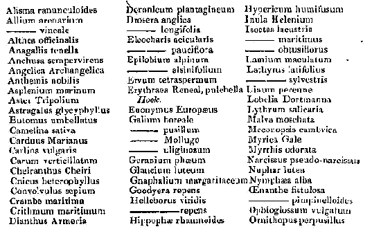
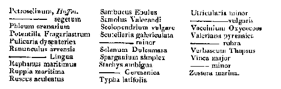
Botany. – The following list of the rarer plants belonging to the parish was kindly furnished to the writer by Major-General Irving, Balmae House.
Forests or Plantations. – The plantations are composed principally of oak, ash, elm, beech, plane, Spanish-chestnut, larch, Scotch-fir, spruce, and silver fir; and partially of alder, birch, hornbeam, horse-chestnut, walnut, gean, maple, lime, laburnum, Huntingdon willow, poplar, balm of Gilead fir, and pinaster.
There is little wood indigenous to the soil, with the exception of a few ash and mountain-ash trees in the glens of Glenlay and Bombie; and along the bank of the Dee, a little below and above the old bridge of Tongland. There are some oaks, in addition to the ash and rowan; and farther up the river, within Culdoch, in the march of Netherthird, there are a few birch.
The other plants and shrubs natural to such localities are, the hazel, hawthorn, sloe, wild dog-wood, crab, black-saugh, whin, broom, buckie and bramble briars, rasp, honeysuckle, and ivy.
There are a considerable number of beech-trees and some elms in St Mary’s Isle, the circumference of the trunks of which reach 8 and 9 feet, and several of them 11 feet. One oak is 10 feet, and a Spanish-chestnut 14 feet in circumference.
On the farm of Kirkland, in the south Cotland field, is a plane tree, the circumference of which is 11 feet, and the spread of the top covers a circuit of 60 yards.